
The force that best understands the weather is most often the force that wins.
Throughout the history of conflict, commanders who could harness weather insights reaped strategic advantages, while those who neglected to account for weather often fell victim to catastrophic campaign failures.
Operation Eagle Claw, the special operations mission to rescue American hostages in Iran in 1980, failed in part as a result of unforeseen dust storms. Eight service members were killed and the hostages remained captive for seven more months. The failure made clear the importance of environmental monitoring.

Lt. Col. Tim Ryan, USAF (Ret.) is a Senior Resident Fellow for Space Studies at the Mitchell Institute for Aerospace Studies.
Download the entire report at
More than three decades later, the successful assault on Osama bin Laden’s compound in Abbottabad, Pakistan, was carefully planned around troubling weather. Planners delayed the mission by 24 hours due to anticipated surface winds and thunderstorms. Without the ability to accurately forecast weather, the mission might well have been a failure.
Successful environmental monitoring requires a broad range of sensors operating in the air, at sea, on land, and in space. Of these, space-based is arguably the most crucial, given its unique ability to rapidly and persistently surveil and measure a vast expanse of territory. In remote regions of the world, this ability to sense from a distance is particularly important. Space-based environmental monitoring (SBEM) satellites capture insights to model and predict cloud cover, surface wind speed and direction, wave heights, snow depth, soil moisture, and more—anywhere on the surface of the Earth.
Chief of Space Operations Gen. B. Chance Saltzman recalled how in the 2003 Iraq War, U.S. commanders were able “to keep track of a maneuvering Iraqi army through a sandstorm,” and to later strike the unit with precision munitions once the storm was over. “This had a devastating effect on the [Iraqi] army, both physically because we were hitting the army, but also mentally,” Saltzman recalled. “They had no idea how we were able to track them through the weather through the night. And a lot of that, of course, was enabled by our space-based ISR capabilities as well as the munitions that we employ with GPS precision.”
Thanks to weather intelligence, the U.S. military held a decisive advantage over the Iraqi forces, enabling U.S. leaders to know precisely when and where to strike.
Yet today, the United States faces a critical challenge in maintaining this advantage. The SBEM mission depends on the Defense Meteorological Satellite Program (DMSP), a constellation developed in 1962 and now well beyond its anticipated life span. Individuals at all levels of the military enterprise depend on this capability, yet are unaware the function relies on these aging DMSP satellites.
The DMSP was designed and configured when space was generally considered a peaceful operating domain, engineered and purpose-built to be a large-scale, highly capable, multifunction system. Losing one satellite today would cut the current operational constellation by half.
Today, with adversaries increasingly contesting space operations, a numerically larger, more disaggregated set of capabilities is needed to reduce risk and increase resilience. The urgency to move quickly is clear.
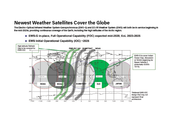
In 2016, a Joint Requirements Oversight Council (JROC) study on recapitalizing the space-based environmental monitoring satellite architecture reviewed an Analysis of Alternatives (AOA) executed in the 2010s, leading to the selection of the Electro-Optical/Infrared Weather Systems (EWS) and Weather Satellite Follow-on Microwave (WSF-M) programs to meet modern sensing requirements.
While this recapitalization effort is designed to provide better resiliency through far more modern, capable satellite systems, it initially calls for fielding demonstration satellites, followed by additional satellites later to deliver the required quality and quantity of weather information. To improve revisit rates and increase near-real-time weather data will require a constellation of a dozen or more satellites. This increased number also guards against the risk that an enemy might try to knock out SBEM capabilities. Importantly, while the JROC study identified the core capabilities of the SBEM architecture, the plan for these capabilities predates concepts like Joint All-Domain Command and Control (JADC2).
In the meantime, leaders are augmenting U.S. SBEM capabilities with a family of systems (FoS) approach, combining data from other weather sensors on orbit through partnerships with the National Oceanic and Atmospheric Administration (NOAA) as well as U.S. allies. This ensures access to weather data in the interim, but is not a full-on replacement. Gen. Glen D. VanHerck, commander of U.S. Northern Command and NORAD, warns against dependence on sources of critical information that might not be available when needed most: “The thing we have to ask is do we want to find ourselves where an individual or a business can impact national security by their perception or their political views? And we find ourselves in a situation where now they’re impacting our ability to conduct operations around the globe.”
Commanders will struggle to meet mission objectives if DOD fails to field its own modern environmental monitoring capabilities.
Fundamental to JADC2
Gen. David Thompson, former Vice Chief of Space Operations“Every DOD operational mission begins with a weather briefing; either space weather, terrestrial weather, or both. The data required for DOD missions is often unique and necessitates 24/7 global ability to forecast weather in austere and denied environments.”
12 Essential Weather Requirements
The Air Force identified 12 mission-critical space-based weather capability gaps in 2009, most of which were later affirmed by the Joint Requirements Oversight Council to be core requirements for future weather satellites:
| Capability Area | System Addressing | |
|---|---|---|
| 1 | Cloud Characterization | EWS |
| 2 | Theater Weather Imagery | EWS |
| 3 | Ocean Surface Vector Winds | WSF-M |
| 4 | Ionospheric Density | NOAA |
| 5 | Snow Depth | WSF-M |
| 6 | Soil Moisture | WSF-M |
| 7 | Equatorial Ionospheric Scintillation | Ground Sensors |
| 8 | Tropical Cyclone Intensity | WSF-M |
| 9 | Sea Ice Characterization | WSF-M |
| 10 | Auroral Characterization | Scientific use only |
| 11 | Energetic Charged Particle Characterization | WSF-M |
| 12 | Electric Field | NOAA |
Weather impacts all levels of warfare, from tactical to strategic. Environmental data plays an important part in closing kill chains to help get the right shooter to the right place at the right time to provide the right effect. Analysts must use imagery and data to determine which sensors have the best line-of-sight and then select the correct weapon given weather and environmental conditions. Weather data will be crucial to Joint All Domain Command and Control, which will demand near-real-time weather data to facilitate dynamic operational planning and to respond to emerging threats.
In the Arctic and Western Pacific, both regions in which the U.S. anticipates heading off conflict, weather data from terrestrial sources is sparse. SBEM will be crucial, therefore, to fight and win. Consider an aircrew getting ready to launch on a sortie: They need to know about wind speed, icing temperatures, lightning, cloud cover, visibility, sand/dust conditions, and severe weather precipitation. Those factors will impact the entire operation, from when an aircraft can take off and land to which sensors it should employ and what munitions it might expend. They also affect essential support functions, such as search and rescue and intelligence, surveillance, and reconnaissance (ISR) activities.
As decision cycles accelerate, and pressure mounts to empower decisions in the span of hours and minutes across an entire theater, near-real-time weather data will become still more important. Without timely, accurate weather data to inform decisions, commanders face mission failure.
In the Indo-Pacific theater, where U.S. forces will need to transit long distances and fight through complex weather patterns, the lack of land- and ocean-based sensors leaves a gap between available data and the unknown. Satellites are the most efficient way to fill this gap.
SBEM Challenges and Future Requirements
Lt. Col. Joe Maguadog, Space Systems Command, EWS Program Manager and Material Lead“The Space Force Space-Based Environmental Monitoring capabilities provide key global terrestrial and space weather data for DOD to plan, execute, and assess daily mission operations.”
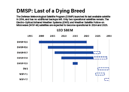
Built as an exquisite, fully capable SBEM suite, each DMSP satellite hosts seven sensors and answers a broad spectrum of weather sensing requirements. DMSP can “see” a range of environmental factors, from cloud cover to pollution, and collect data to measure cloud type and height, land and surface water temperatures, and more. The satellites can even measure charged particles and electromagnetic fields in space, factors that affect military radars, communications, and satellite operations. Yet while DOD has refreshed these satellites over time, its backfill supply is now exhausted; the last DMSP satellite launched in 2014, leaving the enterprise on a terminal trajectory with no backfills available.
Over the past two decades, two weather satellite programs that might have addressed this shortfall were canceled, both without ever delivering operational capability. The National Polar Orbiting Environmental Satellite System (NPOESS), canceled in 2010, and the Defense Weather Satellite System (DWSS), canceled two years later—left in their wake a devastated national security weather enterprise. The Air Force launched a refurbished 1990s-constructed DMSP satellite in 2014 as a band-aid solution, and that satellite went offline in 2016 after a catastrophic power failure. Lacking another DMSP satellite to launch, the Air Force reassigned its only remaining retired, on-orbit backup DMSP satellite to a primary system role to fill the gap and meet operational requirements.
To solve this long-term challenge, the Air Force identified 12 potential mission-critical capability gaps in space-based weather, beginning in 2009. Most of these gaps were later highlighted in the JROC study and remain important core requirements for future weather satellite operations: Cloud Characterization, Theater Weather Imagery (TWI), Ocean Surface Vector Winds, Ionospheric Density, Snow Depth, Soil Moisture, Equatorial Ionospheric Scintillation, Tropical Cyclone Intensity, Sea Ice Characterization, Auroral Characterization, LEO Energetic Charged Particle (ECP), and Electric Field.
Defining the Path Forward
In 2016, the Air Force revised its plans based on the requirements set by the JROC study, determining it should replace the monolithic Defense Meteorological Satellite Program with two disaggregated, small satellite constellations, which would together contribute to the desired family of systems model. These are the EO/IR Weather System (EWS) and the Weather System Follow-on Microwave (WSF-M) programs.
Replacing a single large system like the DMSP with multiple systems like EWS and WSF-M operating in their respective constellations promises numerous benefits: improved resilience and more rapid technology updates, delivering progressive constellation modernization.
Electro-Optical/Infrared Weather System (EWS) program
EWS cloud characterization sensor capabilities are imperative to supporting flying operations, from understanding sensor visibility to determining icing conditions on aircraft wings. Characterizing cloud cover is also foundational to understanding missile warning timelines and the capability to provide timely missile warning to fielded forces, allies, and partners.
Col. Brian Denaro, Space Systems Command’s Space Sensing Program Executive Officer, stated, “EWS continues to blaze the trail on numerous space acquisition tenets. The program is building smaller satellites while minimizing non-recurring engineering.” Given the age of DMSP, the criticality of EWS to satisfy the two highest SBEM priorities can’t be overstated.
Weather System Follow-on Microwave (WSF-M) Program
WSF-M will operate from a low-Earth orbit, using a next-generation passive microwave imager to collect terrestrial weather information and space environment observations. Projected to launch in late 2023 and become operational by mid-2024, it would be replaced just a few years later by a second WSF-M satellite to be launched in 2028. WSF-M will support meteorologists in generating the weather products necessary for daily global mission planning and operations in a few ways. This single satellite will address six SBEM gaps: It will provide the ocean surface wind speed and direction measurements needed to support naval maneuver operations and aircraft takeoff and recovery; it will provide tropical cyclone intensity measurements and predictions, enabling critical warnings to impacted areas and informing military operations likely to be affected by extreme weather conditions; it will use state-of-the-art algorithms to measure snow depth, soil moisture, sea ice thickness, and sea ice characterization; and finally, WSF-M addresses gaps in characterizing energized charged particles by taking measurements in space to determine space weather impacts on satellites and limit disruptions to HF communications and SATCOM.
Delivering What the Warfighter Needs
The growing air and missile threats to the U.S. homeland require access to clear and accurate environmental data, notes Northcom’s VanHerck : “To defend our homeland, we must be able to operate in the Arctic, and that requires domain awareness, which also is the weather aspect of that.”
Today’s two operational DMSP satellites provide only enough coverage to refresh weather data every 10.5 hours. The JROC requirement, however, is a four-hour refresh rate, which would require three satellites. But modern warfare demands still greater accuracy. Consider what happened when the U.S. identified a balloon over North America earlier this year. Lt. Gen. David S. Nahom, commander of Alaskan Air Command and 11th Air Force, described the response: “In January, in Alaska, in the middle of a blizzard, we had F-35s taking off 30 minutes before a blizzard hit with no idea how they’re getting home. You had tankers taking off in the middle of a fight. You had snowplow drivers working around the clock trying to keep the runways clear. You had HH-60 Air Force rescue guys flying through the valleys of the Brooks Range at night in NDGs in a snowstorm. [Weather] is absolutely on our mind and how we predict it.” The reality is warfighter demands will be closer to one-hour refresh rates with highly accurate short-term forecasts. This will require a bare minimum of 12 satellites to satisfy the dynamic, high-tempo operations both in the harsh environment of the Norther Tier or in a JADC2 environment.

Recommendations
The current SBEM enterprise risks collapse with the end of the operational life of the DMSP satellites. The time to develop and field new technologies has run out and uncertainty over DMSP’s life expectancy and volatile defense budgets leave little buffer. Grasping the seriousness of the situation and to assure the future success of this mission, the time to field EWS and WSF-M and enact the following SBEM enterprise reforms is now:
Congress must protect DMSP replacement efforts. The NDAA should fence EWS and WSF-M for defense requirements only and avoid repeating the past delays, complexities, and dysfunctions involved with merging many government agency requirements into an interagency program in the name of efficiency. Certainly, environmental data from defense-dedicated programs should be appropriately shared. However, the U.S. military is facing the potential for peer conflict without the assurance of weather data support it needs to maximize its ability to project power and employ effectively. Non-defense needs should not delay or suboptimize the rapid replacement of space-based environmental monitoring that underpins weather support to the warfighter.
The U.S. Space Force must continue to develop a resilient SBEM architecture. Adversaries have clearly articulated their intent and demonstrated their ability to disrupt and destroy U.S. space capabilities. To mitigate this risk, the Space Force must continue to embrace a disaggregated SBEM architecture to provide resiliency with smaller, less expensive platforms to offset the loss of one or two systems. The current weather strategy distributes the sensor capabilities from DMSP to EWS for EO/IR and WSF-M for microwave. Pending their successful launch and demonstration, they could be the first increment of a resilient, assured SBEM capability. A constellation similar to the sensing footprint of DMSP requires a minimum of 12 satellites to gain a one-hour revisit period: Attrition reserves in orbit would be additive.
The U.S. Space Force must continue to develop SBEM requirements to reflect the current and emerging needs of the warfighter. EWS and WSF-M meet the current requirements established in the 2012 AOA and subsequent JROC study, but the Space Force must continue to update requirements that incorporate combatant commanders’ future needs. The U.S. military faces threats from a peer adversary and is developing JADC2 as the future warfighting concept. This drives new warfighting requirements beyond those identified in the AOA and will be imperative for future success in conflict. The DOD must continue to update its architecture requirements to ensure the provided capabilities meet the needs of the warfighter in 2023 and beyond. Additional satellites are likely part of the solution to boost refresh rates and afford enhanced resiliency.
The U.S. Space Force needs a stable, long-term program of record for SBEM. Lacking a defined program of record creates uncertainty in the SBEM architecture. The space-based environmental monitoring enterprise would benefit from a long-term, stable program of record with requisite defined funding to provide a full constellation of satellites. This program of record should be based on mature technologies and current requirements for future developments. The singular EWS and WSF-M satellites currently under contract will provide capability, but rapidly transitioning to fielding the operational constellation within an established program will provide stability and a resilient architecture in line with warfighter requirements.
Nurturing partnerships is imperative to our weather strategy. Partnerships are critical to the SBEM strategy, especially in the near term, because the DOD does not have enough capability currently on orbit or programmed to cover necessary orbits and revisit rates. Until the DOD delivers the SBEM constellation of satellites envisioned in its family of systems concept, the U.S. cannot generate the SBEM data it needs without a combination of allied, partner, civil, DOD, and commercial capabilities. The DOD partnership strategy must prioritize SBEM data assurance through reliable sources and data availability through all phases of conflict.