When David D. Bradburn entered the US Army Air Corps in 1946, his branch had only the faintest acquaintance with missiles and spacecraft. Bradburn could not have foreseen that, on Dec. 21, 1964, he would be at Vandenberg AFB, Calif., overseeing the launch of a highly specialized spy satellite—but he was.
Bradburn had flown fighters and had racked up 50 B-26 combat missions in the Korean War. In December 1960, however, he moved to the Air Force Office of Special Projects. Shortly afterward, he was selected to be program manager of a classified satellite program. Less than a year later, the Kennedy Administration created the National Reconnaissance Office, and Bradburn became part of it, and so did his program.
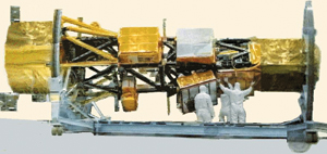 |
Technicians work on a radar-imaging Lacrosse satellite. |
Bradburn’s satellite was given the designation Quill. Quill was a radar imager, an early part of what was, and still is, an extraordinarily challenging US space radar effort. The program yielded a total of three models—two flightworthy spacecraft and a bench model for testing. It was the first of those two flying systems that was propelled into orbit that December.
The concept of space radar was simple: The satellite transmits powerful radar waves toward Earth. They bounce off the target and return to a receiver on the satellite, which captures an electronic image of the target.
Radar waves penetrate cloud cover, and do not rely on the visible light portion of the electromagnetic spectrum. For these reasons, radar imagers, unlike photographic spy satellites, can provide imagery of any target in any weather at any time.
To Bradburn and others in the Air Force, this looked to be a particularly promising technique for detecting nighttime Soviet military exercises and nuclear missile movements.
Like photoreconnaissance satellites, Quill returned images by ejecting a payload capsule, which was then snatched out of the air by a specially modified C-130. The Quill images did not have very high resolution, but analysts still could clearly identify cities, airfields, military formations, and industrial installations. In truth, its target area was highly restricted. It was allowed to “paint” targets only in Ohio, Illinois, Indiana, and Far West states—not the Soviet Union.
Quill’s operational life was not long—only about a month—but that was still longer than was the case for most of the new reconnaissance satellites. On Jan. 11, 1965, its mission ended and the satellite burned up in the atmosphere upon re-entry. That event marked not only the end of that particular satellite but also of the whole space radar program—for a while, anyway.
What killed Quill was fear that the existence of a US reconnaissance satellite that transmitted such signals would spur the Soviets to interfere with those satellites—and also threaten the NRO’s passive photographic satellites.
Even so, that was not the end of the matter. The concept of space-based radar kept bobbing back to the surface. Bradburn, in fact, spent more than 20 years helping develop radar and satellite systems for the Air Force before finally retiring as a major general in 1976. (He died in October 2008.) The Air Force and National Reconnaissance Office, in turn, have been hard at work developing promising but difficult space radar systems. Work on classified programs continues to this day.
Soviet launches of radar-based ocean-reconnaissance satellites in the 1960s may have spurred the US to again consider developing a radar imaging system, specifically a side-looking, synthetic aperture radar, which allowed an image to be constructed from multiple reflections off a target.
On Jan. 20, 1970, the NRO hosted a meeting to discuss plans for testing a side-looking SAR. The Defense Intelligence Agency believed North Korea, with an abundance of ground targets, would be the best place on which to focus.
However, the National Photographic Interpretation Center had an alternative—Cuba. NPIC preferred the island because it had many and varied targets accessible to side-looking radar, the US had a large database of information about Cuban targets, and the US could test the radar’s powers of “change detection” by obtaining around-the-clock, all-weather coverage.
Cuba was selected as the best test target for a new radar imaging system.
Later that year, NPIC hosted another meeting to discuss side-looking satellite radar imagery. There were two projects to be discussed—the QU [Quill] Follow-on SLR Project and the Advanced Strategic SLR System—both of which were being managed by the NRO. Officials believed that a Quill follow-on with 10-foot resolution would meet requirements for oceanic surveillance and indicators and warnings.
It was the NRO Advanced Strategic SLR System that was to be tested on Cuban targets.
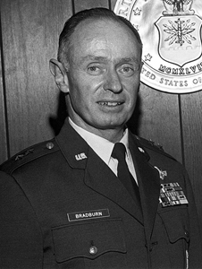 |
Maj. Gen. David Bradburn, a space radar pioneer. |
Looking At Cuba
In April 1971, under a program designated Senior Lance, U-2Rs equipped with side-looking radar began flying along the coast of Cuba to verify the value of radar imagery on targets in Cuba.
The declassified record is silent concerning the NRO’s pursuit of radar imagery satellites during the remainder of the Nixon and Ford Administrations.
One problem that did not go away was the cloud cover over the Soviet Union and Eastern Europe. As one defense official of that era put it, “The weather in the Soviet Union is crappy all the time.” Obtaining a satellite photo of a target could take years.
During his tenure as director of central intelligence in 1976-77, George H. W. Bush approved a radar satellite program designated Indigo, and assigned responsibility for the program to the Air Force Office of Special Projects.
Bush’s successor as DCI, Adm. Stansfield Turner, recalls that during his tenure, the CIA proposed an alternative—adding a radar imaging capability to future KH-11 electro-optical satellites, the first of which was launched in December 1976.
Turner characterized the proposal as “an ingenious solution” to the problem of cloud cover, because “if a target were obscured temporarily, the satellite could switch quickly from optical pictures to radar ones and be sure of getting something.” Turner recommended setting aside funds to procure radar-augmented KH-11s.
He also recalls that Defense Secretary Harold Brown “immediately saw the benefits of this combined optical-radar satellite” and agreed it should be developed by the CIA.
Turner was therefore confident that President Jimmy Carter would approve the program. But what “I did not foresee,” Turner has written, “was the pressure that would beset Harold from below.”
“Below” in this case meant the Defense Department and the Air Force, which convinced Brown to support a separate, Air Force-led, radar-only system.
When the two put their cases before Carter, “Harold deftly out-argued me, refuting the points on which we had agreed just hours before,” Turner said. Brown said the CIA approach placed too many eggs in one basket—a failure in space or a launch failure would deprive the US of both sensors simultaneously.
Furthermore, two sensors on the same satellite couldn’t be in two places at once. A radar-only satellite would mean that while a KH-11 photographed a target in China, a radar satellite might be thousands of miles away, imaging tank movements in Ukraine.
Carter sided with his Secretary of Defense, and the Air Force got to keep its radar satellite program—for a few years at least. But, by the middle of President Reagan’s first term, it was apparent that Lacrosse, as Indigo had been renamed, had vast cost overruns and numerous developmental problems. Roughly $200 million was needed to keep Lacrosse alive in 1983.
This set up a showdown in the Congressional intelligence oversight committees. Edward P. Boland, the chairman of the House Permanent Select Committee on Intelligence, believed that the program’s developmental problems were insurmountable.
Barry M. Goldwater, chairman of the Senate Select Committee on Intelligence, argued that U-2 and SR-71 spyplanes experienced similar cost overruns and developmental problems, but ultimately added a vital new dimension to US intelligence capabilities. Goldwater also pointed to the success of the 26th Tactical Reconnaissance Wing, which flew RF-4s out of Zweibrucken AB, Germany, and transmitted real-time radar imagery of targets along the German border.
Lacrosse’s contribution to the nation’s security, he argued, could be immense, was worth the cost, and “could work to prevent war.”
 |
The Greater Washington, D.C., area shown in an image taken by a space radar. One of the benefits of space radar is that it can penetrate clouds. |
Enter the Onyx
Boland agreed to one year’s funding, and Goldwater agreed that further cost overruns would result in the project’s demise.
The first Lacrosse satellite was completed in October 1987, by which time the satellite’s code name had been changed to Onyx.
Martin Marietta’s James McAnally apparently played a key role in resuscitating the program. Named an NRO pioneer in 2004, the press release of his citation noted that he led “the development of a new satellite reconnaissance system capable of imagery essential for a wide range of operations,” which “provided unique and critical intelligence information.”
“When McAnally took over the program’s management, it was experiencing serious financial and technical difficulties,” another declassified NRO document stated. “In an effort to prevent imminent program cancellation, McAnally worked funding issues, and streamlined business management.”
Onyx was ready to go in 1988, but its launch vehicle, the space shuttle, was not. The shuttle was still grounded after the 1986 Challenger disaster. After a successful shuttle mission in September 1988, NASA scheduled a Dec. 1 launch for Atlantis to deliver Onyx to orbit.
The launch site was to be Cape Canaveral, Fla., due to problems with the shuttle launch pad at Vandenberg AFB, Calif. But launching a reconnaissance satellite from the Cape posed one significant constraint. To avoid overflying populated areas on launch, the maximum inclination that could be attained was 57 degrees. With that inclination, radar coverage would stop 100 miles north of Moscow.
Therefore excluded from Onyx coverage would be the naval facilities around the Kola Peninsula, six ICBM sites, and the satellite launch facility at Plesetsk.
High-altitude wind caused NASA officials to postpone the Dec. 1 launch—the loss of the Challenger crew was still fresh in NASA’s mind, and each Onyx was a several hundred million dollar investment.
The next day, at 9:30 a.m., two minutes before the launch window for the day closed, Atlantis lifted off. On the seventh orbit, the payload was released into space.
From a safe distance, Atlantis instructed the two solar panels attached to the central body of the satellite to unfold—and they failed to respond. Fortunately, a second set of radio commands freed the solar arrays. This Onyx bird was intended to be part of a five-satellite Cold War imagery constellation consisting of three KH-11 satellites and two radar imagery satellites.
Within five weeks, the first Onyx—also designated 3101 for the satellite program number (3100) and the mission number (one)—used its on-board rocket engines to reach its operational orbit. It then transmitted its digital imagery, with resolution in the five-to-10-foot range, to its ground station at White Sands, N.M.
The imagery helped monitor Soviet SS-20 missile movements, transportation of nuclear weapons, and other nighttime Soviet military activities. It also assisted in monitoring Iraqi tank movements during Operations Desert Shield and Desert Storm.
Before dawn on March 8, 1991, a Titan IV rocket blasted off from Vandenberg to place the second Onyx (3102) into a 68-degree orbit at 423 miles. Nearly two decades later, No. 3102 remains in orbit.
An image of the satellite obtained by a Russian space surveillance facility showed, in addition to the satellite’s bus, solar panels and a 30-foot dish antenna.
In September 1996, it was reported that the two Onyx satellites were used for bomb damage assessments of two US attacks on Iraqi air defense installations. Specifically, the sensors provided images of the craters made by Navy Tomahawk Land Attack Missiles.
In 1997, the first Onyx spacecraft deorbited, burning up in the atmosphere. That October, a Titan IV blasted off from Vandenberg, carrying 3101’s replacement, again into orbit with a 57-degree inclination.
According to a senior Pentagon official, the satellite was an upgraded version with improved “granularity”—resolution good enough to identify an armored vehicle and differentiate between a tank and an armored personnel carrier.
Replacing 3102 was next, and the fourth Onyx was launched on Aug. 17, 2000 from Vandenberg aboard a Titan IV-B. The 30,000-pound satellite was eventually maneuvered into 425-mile orbit, with an inclination of 68 degrees.
The NRO announced in a press release that it owned the payload launched that day, but did not reveal the satellite’s name or mission. An unclassified shoulder patch the NRO distributed to employees to commemorate the launch was more revealing, however. The patch announced that “We Own the Night.”
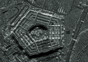 |
A high resolution airborne synthetic aperture radar image of the Pentagon, Arlington, Va. In the 1970s, earlier airborne radar imagers gathered intelligence on targets in Cuba. |
Joint Development
The patch soon became the subject of an article in the Washington Post. The phrase “We Own the Night” of course indicated that the satellite was effective at night, when a visible-light imagery sensor would not be. In addition, four bird shapes, shown crossing the equator at inclinations corresponding to past Onyx launches, represented the four previous radar imagery satellites that had orbited.
The launch of the fifth Onyx spacecraft, reported to have two-to-three-foot resolution, took place April 29, 2005 from Cape Canaveral. Five days later, it was in its operational orbit of 445 miles.
That Onyx is reportedly the last of its line.
The nature—and even the fate—of a follow-on system is unclear. In September 1999, the NRO awarded a multibillion dollar contract to Boeing for the Future Imagery Architecture program. Boeing was to develop a follow-on to both the advanced KH-11 and Onyx satellites.
Eventually, due to technical difficulties and escalating costs, NRO pulled the plug on the electro-optical part of the project, but the radar imagery component survives.
By this time, the Air Force, NRO, and Defense Advanced Research Projects Agency had agreed to jointly develop a spacecraft with a synthetic aperture radar and moving target indicator capability. The objective of the system was to provide near-continuous surveillance between 65N and 65S latitudes, and the ability to track targets.
Boeing continued with its separate, NRO-funded, Onyx follow-on program.
Then, in 2005, DCI Porter Goss and Defense Secretary Donald H. Rumsfeld signed a memorandum of agreement stipulating that the joint NRO-Air Force Space Radar program would also serve as the radar imagery component of FIA.
That required Congressional committees to approve the ambitious effort—and the extraordinary cost of developing a system that would satisfy military requirements. This is something Congress has proved reluctant to do: Lawmakers ultimately deleted all funding for the joint program from the spending bill it passed on Sept. 24, 2008.
It now appears that the next descendant of Quill will be built by Boeing as first planned in 1999 and possibly funded solely by the NRO.
 |
An artist’s conception of the notional joint NRO-Air Force Space Radar. The program’s fate is unclear: In 2008, Congress cut off all funding. |
In October, when NRO Director Scott F. Large was asked if there would ever be a joint NRO-DOD radar imagery system, he said, “I certainly hope so.”
But Large also indicated that NRO was proceeding on its own to develop a system to satisfy intelligence and military customers.
Developing these advanced radar imaging systems has never been easy, but for more than four decades DOD and the Intelligence Community have found it worth the effort and expense—up to a point.