Satellites built for detecting and tracking missile launches are of high import for the US and its national security. They provide the nation and its military forces with notice of possible missile attacks and space launches worldwide.
“No rocket takes off anywhere in the world without us seeing it,” Gary E. Payton stated flatly in a July interview just prior to his retirement as Air Force deputy undersecretary for space programs. The Pentagon’s Defense Support Program has played the lead missile-warning role for decades, but the long-anticipated Space Based Infrared System will soon launch its first space vehicle into geosynchronous Earth orbit (GEO).
Payton was optimistic the heretofore troubled, next-generation SBIRS will substantially bolster US capabilities in detecting space launches.
After experiencing years of development problems and cost overruns, the Air Force is eyeing 2011 as the year a dedicated SBIRS satellite goes into orbit. This bird will complement two SBIRS sensors that are already in use, hosted on classified satellites in high elliptical orbit.
 |
In an artist’s conception, SBIRS GEO-1 detects a nuclear emission source. ( Illustration by Erik Simonsen) |
As one senior Air Force official admitted, SBIRS “has not exactly been a model acquisition program” since its 1996 inception. In 2001, the Pentagon made the first of what would be several Nunn-McCurdy notifications to Congress for cost growth, forcing the program to be restructured. Many more restructures and notifications of cost increases would follow, but Air Force officials now finally seem certain that the SBIRS program is out of the woods.
Over the summer, military engineers and those working for prime contractor Lockheed Martin completed system testing on the first SBIRS GEO satellite, designated GEO-1, and planned for delivery to Cape Canaveral, Fla., early next year.
“We are marching towards a spring 2011 delivery date, targeting right now the March time frame … with the intent of getting it launched shortly thereafter,” Col. Roger W. Teague said in June.
Cutting No Corners Teague is the commander of the SBIRS wing at the Space and Missile Systems Center, Los Angeles AFB, Calif., and manages both the legacy Defense Support Program and the follow-on SBIRS effort. Teague said SBIRS GEO-1 still has a shot at making the Fiscal 2011 launch manifest.
The satellite was previously scheduled to be delivered to the Cape later this year, but Teague said extended testing of the flight software redesign pushed the delivery date to the spring.
“That development has gone extremely well,” he added. “We’re in the final stages of now qualifying that software before we launch it.”
He explained that qualification stresses the software in ways that mimic “anomalous conditions” the satellite might experience while on orbit. “Given the journey that we’ve had so far, it doesn’t make sense to cut any corners from a mission assurance standpoint,” Teague added. SBIRS GEO spacecraft will have both scanning and staring sensors. Pointing mirrors in front of the telescopes will allow the system to hone in on specific parts of the world. The scanning sensor is expected to provide a shorter revisit time than the DSP over its full field of view, while the staring sensor will be used for step-stare or dedicated stare operations over smaller geographic areas.
The GEO staring sensor is also built to stare at one Earth location and rapidly move to other locations, with improved sensitivity compared to DSP. Several areas can be monitored by the staring sensor, with revisit times significantly quicker than DSP.
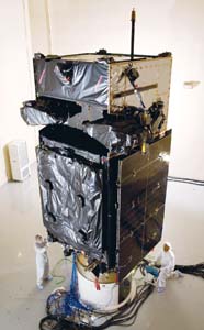 |
SBIRS GEO-1 is prepared for thermal vacuum testing at a Lockheed Martin Space Systems facility. ( Lockheed Martin photo) |
The SBIRS constellation is someday expected to replace completely the old DSP constellation, which currently serves as the main US early warning system for missile launches around the world.
DSP has been operational for almost four decades. Several replacement programs were started throughout the 1980s and 1990s, but none came to fruition. These earlier attempts reportedly failed due to immature technology and high cost.
But the true genesis of the SBIRS program as it is currently formulated can be found in the events of the 1991 Persian Gulf War. Based on experiences with Iraq’s short-range missile launches, DOD officials concluded more robust theater missile warning capabilities were needed, according to Air Force officials familiar with those discussions. Plans for an improved infrared satellite sensor capability for both long-range strategic and short-range theater ballistic missile warning began shortly thereafter.
In 1994, defense officials studied potential consolidation of various infrared space requirements, such as for ballistic missile warning and defense, technical intelligence, and battlespace characterization, and they selected SBIRS to both replace and enhance the capabilities provided by DSP. But Payton pointed to that very consolidation as a major culprit behind SBIRS’ troubled history.
“In the ’90s, we were looking to save money by combining several missions onto one platform,” Payton explained. “So we jammed four missions onto SBIRS.”
According to industry sources, the program is currently expected to run upward of $15 billion in acquisition costs alone—nearly a fourfold increase over initial projections. Reports by government auditors show that the program has been plagued throughout its history by technological immaturity, unclear requirements, unstable funding, and poor oversight.
Congress, reacting to the developmental problems, responded by significantly cutting program funding on several occasions, throwing the program into further disarray.
In Fiscal 2002, lawmakers denied procurement funding altogether—a total of $94 million—and would only permit the program office to conduct development work at the time. Air Force officials forged ahead while also beginning work on fallback options in the event SBIRS proved unrecoverable.
Lockheed Martin is currently on contract to produce the SBIRS satellites and payloads, while Northrop Grumman is Lockheed’s payload integrator. Because of the developmental problems, the government has on several occasions withheld contract award fees from Lockheed Martin, although Air Force officials decline to provide specific figures. Teague said this summer that, over the years, Lockheed has received fees “commensurate with the work it has performed.”
Payton went a bit further: “There have been times when their award has been zero.”
Officials at US Strategic Command remain concerned about the program’s progress. Despite recent upbeat projections about SBIRS, the system might not be completely ready before DSP satellites begin failing. In late 2009, STRATCOM commander Gen. Kevin P. Chilton sent an urgent-need request to the Air Force’s Operationally Responsive Space (ORS) office for alternatives to augment the mission. Those types of concerns are again surfacing.
Lt. Gen. John T. Sheridan, Space and Missile Systems Center commander, and other space procurement officials have emphasized that DSP has already proved far more robust than expected, however. Several officials said they expect DSP to continue functioning well for another decade or longer.
Gen. C. Robert Kehler, head of Air Force Space Command, has said that AFSPC experts are exploring further life extensions for the DSP constellation. However, because of the time lag in purchasing components for SBIRS GEO-3 and beyond, a coverage gap could still occur if there are more SBIRS delays and Space Command is not able to keep DSP on life support long enough.
In 2005, with concerns about the program’s viability peaking, the Pentagon’s acquisition office ordered the Air Force to develop a competing capability for SBIRS. The Air Force started a parallel effort known as the Alternative Infrared Satellite System (AIRSS).
 |
The Defense Support Program satellite in orbit, in an artist’s conception. SBIRS is the follow-on to this long-lived legacy program, which currently provides notice of rocket launches worldwide. ( Illustration by Erik Simonsen) |
AIRSS, which evolved into the Third Generation Infrared Surveillance system, or 3GIRS, showed early progress. It was first seen as a less expensive alternative and then as a supplement to SBIRS, once prospects for the earlier program had improved sufficiently.
The ORS office continues to explore various options for mitigating any potential missile warning gap. One possibility already being openly discussed by senior officials is preparation of additional sensors produced under AIRSS/3GIRS by Raytheon and SAIC.
The first of these sensors is scheduled for launch next year on an SES Americom satellite, built by Orbital Sciences as a commercially hosted payload experiment. One official estimates that any 3GIRS-based supplement to the mission would cost “a fraction” of what the SBIRS program cost in its first couple of years.
Strong Progress SBIRS ground system and software development also seems to be making solid progress. Researchers in the SBIRS program office at Los Angeles Air Force Base this past summer successfully completed a major system-level test of the interfaces between the ground facilities and the GEO-1 satellite, explained Capt. James Palmer, the SBIRS systems test program manager.
The test demonstrated the command and control capability of the GEO-1 satellite, plus the ability to transmit and receive data between the ground system and the satellite using rapidly changing frequencies, known as frequency hopping.
The ground segment for the system is being developed and fielded in blocks. It will consist of three major components: two fixed operational sites, several relay ground stations, and communications links. Relay ground stations around the world will receive data from the satellites and forward it to the mission control station at Buckley AFB, Colo.
MCS software will create launch reports that include information such as missile type, launch point, time, and azimuth, as well as predicted impact point.
Online since 2001, the MCS operates the DSP satellites today and will have the capability to operate the SBIRS payloads and spacecraft in the future.
Lockheed Martin’s vice president for SBIRS, Jeff Smith, said this summer that the company has 138 scripts running to qualify the redesigned flight software for GEO-1. “We’re about half done with those, and the plan is to complete them in the November timeframe, which would lead up, early next year, to the shipment down to the Cape,” he said. “We just need to make sure that every nook and cranny is wrung out of this before we launch it.”
System testing on the GEO-1 satellite was completed in May, according to Air Force officials. The testing certified “space-to-ground integration verification,” Teague explained. Last fall, the vehicle completed its most important and grueling verification, thermo-vacuum testing, Teague said, describing the event as a “final environmental test to ensure that the satellite would survive and operate in a space environment.”
Similarly, the ground system completed a test that validated its functionality, performance, and operability, he said.
The ground segment of SBIRS consists primarily of the mission control station at Buckley; the mission control station backup at Schriever AFB, Colo.; and the survivable mission control station. In addition, joint tactical ground stations provide deployable downlinks for SBIRS data. The components of the program, both space and ground, are coming together in operational readiness for launch and support of the SBIRS GEO-1 satellite, said Teague.
In the meantime, he said, the GEO-2 satellite “continues to make strong progress.” GEO-2 completed its first phase of satellite-level testing in February. During the four-month event, called baseline integrated system testing, the Air Force ran the satellite through hundreds of “scripted test events” at Lockheed Martin’s plant in Sunnyvale, Calif. The test demonstrated the satellite’s hardware integrity and the functionality of its payload and spacecraft bus, service officials said.
GEO-1 is expected to be available for operational use about 14 months after its launch next year.
If all goes well, GEO-2 should launch sometime in 2012, and is projected to enter operational use roughly six months after that, according to Air Force officials.
Marina Malenic is the Pentagon correspondent for Defense Daily, a Washington, D.C.-based defense newsletter. Her most recent article for Air Force Magazine was “Fighters Far and Wide,” in the January issue.