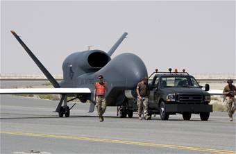
 Air Force officials say the production version of the Global Hawk unmanned aerial vehicle has collected more than 96 percent of the “target deck”—some 5,000 images of enemy resources in the Southwest Asia theater. The UAV surveys large geographic areas with pinpoint accuracy, providing near real-time data, said Capt. Ty Gilbert, senior intelligence duty officer at the SWA combined air operations center. Another prized feature is the ability to re-task the aircraft, such as during a recent aircraft crash in Afghanistan when a redirected Global Hawk enabled USAF to provide crash site photos to rescuers by the time they received word of the crash.
SDA’s Next Phase of Data Transport Satellites on Hold
June 30, 2025
The long-term future of one of the Space Development Agency’s two satellite constellations is on hold as officials study the options for replacing a planned “data transport layer” with one or more commercial solutions. President Trump’s proposed 2026 defense budget...